Warning as ‘weather bomb’ approaches Scotland


 Getty Images
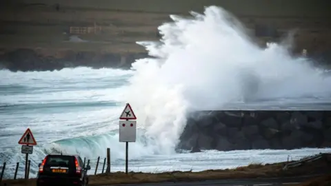
Power cuts, travel disruption and possible damage to buildings are expected this weekend as Storm Ashley sweeps across Scotland, bringing high winds and rain.
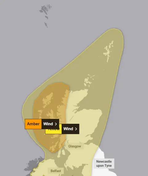
The Met Office has issued an amber high wind warning for some western areas on Sunday, with gusts of 70-80 mph (113-129km/h) expected.
A yellow alert for high winds gusting up to 60 mph (97km/h) covers the whole of the country, and for northern areas will last over the rush hour on Monday.
Meteorologists say Storm Ashley, the first named storm of the season, will see a rapid drop of pressure as it moves in from the Atlantic on Saturday night – a phenomenon called a “weather bomb”.
The phrase is taken from the US term “bombogenesis”, used to described a fall of at least 24 millibars of pressure in 24 hours.
That will result in high winds, which coincide with high spring tides – bringing a risk of large waves and coastal overtopping.
The Met Office said there was a good chance of power cuts in the amber warning area which stretches from Argyll to Cape Wrath in the north, and covers many of the country’s island communities.
Weather warning issued
There could also be damage to buildings such as tiles blown off, some bridge and road closures, train cancellations and a risk to life from high waves during the amber alert period from on Sunday, which runs 09:00 until midnight.
A yellow warning for the entirety of Scotland and Northern Ireland, and parts of north-west England and Wales is in place between 03:00 and midnight.
It continues across the north of Scotland until 09:00 on Monday morning.
Flood warnings – meaning flooding is expected – have also been issued by the UK’s environment agencies.
In England, Sunday’s Great South Run has been cancelled. The 10-mile race in Portsmouth was pulled after organisers said they could not safely deliver the event due to the weather.
Some ferry routes in Scotland have already been completely cancelled on Sunday, including Ardrossan – Brodick, Troon – Brodick, and Oban – Castlebay.
CalMac has warned that more services could be cancelled at short notice on Sunday and Monday. Passengers are urged to check the status of their ferry ahead of time.
And major weekend works on Longacre Bridge which carries the M8 motorway near Chapelhall in North Lanarkshire have been postponed until 25-28 October.
In Argyll, the Old Military Road has been opened while the A83 Rest And Be Thankful is closed due to the forecasted heavy rain, Bear Scotland – who maintain the roads – said.
 Met Office
Transport Scotland spokesman Danny Chalmers told BBC News that people across Scotland should be on “high alert”, and all areas could expect some travel disruption on Sunday.
He said: “Please take extra care because this is the first named storm of the season and people may be unused to driving to these very, very windy conditions.
“We had a record-breaking number of storms last year, so we’re asking people to check before they travel and allow extra time for their journey.
“When you get gusts of 80mph, there’s obviously going to be a significant impact on the ferries and speed restrictions on the rail travel and bridges. Police Scotland have been very clear that there is going to be an impact on transport.”
 Getty Images
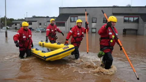
He acknowledged that a lot of people were still suffering from the aftermath of last year’s storms, particularly those in Brechin, Angus, who were battered by Storm Babet and had still not returned to their homes.
Mr Chalmers added: “It’s just impossible to predict how many of these storms we’re going to have unfortunately.”
He said the winds were likely to particularly affect HGVs and other drivers should be on the lookout for fallen trees or debris on the roads.
Ch Supt Hilary Sloan, head of road policing at Police Scotland, urged drivers in the amber alert area to plan ahead.
“If you are travelling, make sure your vehicle has sufficient fuel and is completely roadworthy,” she said.
“Ensure your mobile phone is fully charged in the event you need to call for assistance and if it is likely you may be within your vehicle for long periods of time, take additional clothing and water with you.”
The Met Office also advises people to check for loose items outside their home such as trampolines or garden furniture.
Train operator ScotRail also issued advice ahead of expected disruption on Sunday, urging those travelling to check their services are still running.
Scott Prentice, the strategy and planning director at the operator, added: “In order to keep our customers and staff safe, speed restrictions will be in place as a precautionary measure on some routes in Scotland, which will mean longer journey times.”
Meanwhile Network Rail said several routes across the country will be subject to speed restrictions, including Aberdeen – Dundee and the West Highland line.
The operator’s maintenance teams will carry out additional checks ahead of the extreme weather in areas known to be at risk of flooding.

Storm Ashley will pack a punch
Storm Ashley will pack quite a punch in terms of wind strength, with storm force gusts of 70 – 80mph forecast in the amber warning zone, and 50 – 70mph gusts elsewhere across Scotland.
The timing of this storm will also heighten its impact. The current high tides because of the full moon will increase the risk of coastal flooding and disruption.
This early in the season, lots of trees are still in full leaf which makes them more likely to be damaged or even downed in the strong winds.
And in many cases garden furniture and toys are still out – so make sure anything that could be blown away is secured.
The strongest winds are likely to be later on Sunday afternoon, lasting through the evening period and the first part of the night.
It’ll still be very windy on Monday, especially in the north, but the winds will slowly moderate as the day goes on. Tuesday and Wednesday look like quieter days.
#Warning #weather #bomb #approaches #Scotland